“Landscape, which looks so constant, is on the move. The mountains dream on the horizon, but mountains are just passing through. I watch them, wearing, grinding, rising up out there, their motion still the main beat.”
JILL FRAYNE, STARTING OUT IN THE AFTERNOON
This post is part of the Introduction to Geology series. The post introduces the concept of geomorphology to geotechnical engineers.
Geomorphology
Geomorphology is the branch of geology that studies the formation of the shape of the earth’s solid surface. The science tries to explain specific landforms that we see all around us, such as mountains and valleys, lakes and great river plains. Geomorphology asks what are the landforms origins, what are the geologic processes involved in their formation, and what is their composition?
In general, three factors control the formation of a particular landform:
- The earth materials (their composition and structural relationship);
- Geologic processes acting on the earth materials; and,
- Time over which these processes act.
The earth materials, such as minerals, rocks, soils, and their structures will be covered in detail in future posts.
Geologic processes can be described according to the origin of their activity:
- On the earth’s surface, including weathering, gravity, surface water, ice, glaciers, wind, volcanic activity, the actions of plants and animals and humans, and the combination of these processes.
- Below the earth’s surface, including groundwater, tectonic, and plutonic processes.
- Extraterrestrial, including asteroid impacts.
Future posts will be devoted to each of these major processes. Geologic time is incomprehensible to the human mind. For a species whose average lifespan is 70 years and whose records only go back a few thousand years, how can we put into context timespans that take thousands, millions, or billions of years to shape the planet? A future post will be devoted to why geologic time is important to engineers.
Why is it important to Geotechnical Engineers?
If we can find the particular landform(s) at a project site, then geotechnical engineers can make informed estimates on the following:
- How the landform(s) was formed and the geologic processes involved;
- What soils and rocks likely exist at the site; and,
- What are their likely engineering properties.
My posts on the different geologic processes will be organized in this manner.
The insights from geomorphology help us predict engineering problems at the site. Geomorphology aids geotechnical engineers by providing an understanding of a site before we go out and drill our first boring or run our first test. A good geomorphologic understanding of the simplicity or complexity of a site can inform the number and location of borings, the depth and frequency of sampling, and the amount of risk inherent to the site.
Example
To show the power of geomorphology for geotechnical engineers here is an example of a site at the base of a mountain.
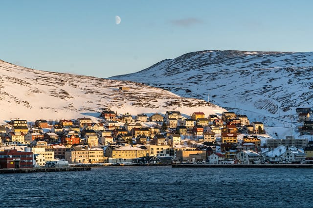
Imagine you are contracted to provide recommendations on a new building in the town here. From the photo you can find two primary geologic landforms, one is the two mountains above the village, and the second is the valley or depression between the two of them.
- Based on your knowledge of geologic processes, the mountains signify that there may be active tectonic processes in the area. Tectonics caused the rock to fold and push up to create the mountains; so, seismicity may be a site hazard.
- From the type of rock in the mountains you can get an idea of the child soils that are produced and how susceptible the mountains are to weathering and what type of weathering.
- The presence of snow may indicate permafrost layers that need to be accounted for in your foundation and basement designs.
- The valley between the two mountains may indicate historic glacial processes that make your soils over-consolidated or may have left pockets of dense gravel.
- The valley could also house a preferential groundwater flow or surface water flows in the non-winter seasons affecting erosion, subsurface deposition, and potential construction techniques.
With the help of a photo and some geologic maps, much can be learned about a site without ever visiting. This knowledge can help you write the winning proposal and inform your engineering recommendations to create a winning project.
Where to learn more?
The intent of my posts is to strike a sense of curiosity in my readers and get my readers to appreciate the larger picture of the world in which we geotechnical and civil engineers work. Hopefully, this post gets you to ask the right questions to best serve the safety of the public and your client’s goals.
Every project is a team process, and no individual can know everything. It is important to consult local expert geologists and geotechnical engineers who understand local conditions and processes. I hope that this post informed you, but it is not intended to be a replacement for professional education and a lifetime of experience. If you would like to learn more then I recommend taking a class in geology. I’ve personally learned a lot from the following two books in my education of this topic:
- Holtz, R., Kovacs, W., and Sheahan, T. (2011). An Introduction to Geotechnical Engineering, Second Edition.
- Parriaux, Aurèle. (2009). Geology, Basics for Engineers.